 |
Dedication: Saint Ann Location: cairnborrow Coordinates: 57.44923N, -2.91492W Grid reference: NJ451402 Heritage designation: none |
HOME - SCOTLAND - ABERDEENSHIRE
|
Dedication: Saint Ann Location: cairnborrow Coordinates: 57.44923N, -2.91492W Grid reference: NJ451402 Heritage designation: none |
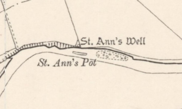
St Ann's Well, located just to the north of the River Deveron, has almost certainly been venerated for centuries. According to Canmore's heritage database, the well was originally held in much repute for the curing of diseases (although it does not specify which, if any, the well was particularly noted to heal). In 1972, the well was described as "a natural spring issuing from a short stretch of dry-stone walling revetting the slope, into a modern white enamelled trough" by OS surveyors.
I have thus far been unable to find any historical references to St Ann's Well, apart from its inclusion on Ordnance Survey maps. It appears to be one of those holy wells that has been unlucky enough to have had nothing recorded of its history. It has long been named on OS maps, however, and, until around 1930 or so, a "St Ann's Pot" was marked near it. It is very likely that this took the form of some sort of pool that could be used for bathing.
Currently, the condition of St Ann's Well is unknown, although its continued presence on Ordnance Survey maps hopefully means that it still exists.
|
Access: The well is located on private land. |
Images:
Old OS maps are reproduced with the permission of the National Library of Scotland
Copyright 2025 britishholywells.co.uk