 |
Dedication: Saint Edburg of Aylesbury Location: Bicester Coordinates: 51.90329N, -1.1742W Grid reference: SP569230 Status: uncertain |
HOME - ENGLAND - OXFORDSHIRE
|
Dedication: Saint Edburg of Aylesbury Location: Bicester Coordinates: 51.90329N, -1.1742W Grid reference: SP569230 Status: uncertain |
There are a considerable number of English saints named "Edburg", all of whom seem to have lived at roughly the same time and to have been quite closely related to each other. According to volume 4 of The Penny Cyclopaedia, published in 1835, there are at least seven recorded saints known as "Edburg", although there may once have been more. There can be almost no doubt, however, that the particular saint associated with St Edburg's Well and with Bicester as a whole is the 7th century St Edburg of Aylesbury, sister of St Edith of Aylesbury and the aunt of the famed St Osyth. Both Edburg and Edith are said to have been born in the now abandoned medieval village of Quarrendon, only a short distance from Aylesbury, where the two reputedly founded a convent, before spending most of their lives there as nuns. Edburg's relics were most probably held either at Aylesbury or at Quarrendon (where she is reputed to have initially been interred) until around 1182, when a man named Gilbert Bassett founded an Augustinian priory at Bicester, and placed it under the joint patronage of St Edburg and St Mary. Edburg's relics soon found their way into the possession of the priory, where they were housed in an elaborate shrine.
Unsurprisingly, the cult of Edburg quickly developed in Bicester, and her feast day was subsequently celebrated yearly in the area. In fact, it is said that what became known locally as the "Yadbury Wake" after the Reformation was actually a corruption of "the Edbury-Wake", or wake of St Edburg. According to James Charles Blomfield, writing in The History of Bicester in 1884, this day also attained the title of "The Feast of the Relics", because pilgrims were then "permitted to view the relics" of St Edburg, after "making their offerings" at her shrine; undoubtedly the nearby holy well would have played some undocumented part in the festivities. It is also said that special plays, detailing the lives of particular saints, were staged in the town on the day for the enjoyment of pilgrims, with the monks of the priory playing the characters.
As St Edburg herself does not seem to have had any link to Bicester until her relics were moved there in around 1182, it is incredibly unlikely that the holy well existed before the foundation of the priory. Almost certainly, the monks or prior created this holy well with the purpose of making Bicester a more attractive destination for pilgrims, and they definitely appear to have been invested in ensuring the well's success as a pilgrimage destination of its own, because they created a special footpath, or "highway", leading directly from the priory to the well, exclusively for the use of pilgrims. White Kennett, who noted in his Parochial Antiquities in 1695 that the path led to "no other place but directly where it terminates" (St Edburg's Well), attested that this trackway was recorded in a document of 1282 as both "Seynt Edburg hes grene way", and "Via Sanctæ Edburge"; clearly the well and path had been created within the first century of the priory's existence.
Unfortunately, it is not evident, however, exactly how pilgrims to Bicester would have used St Edburg's Well, and what would have motivated them to walk over a mile to it from the priory. It is possible that there was some kind of chapel located over the well, which definitely would have attracted pilgrims, and the spring itself was probably claimed to be efficacious in curing some particular and unusual ailment, something which the most popular medieval holy wells always boasted. It was certainly an important site, as it was located directly on the parish boundary, according to historic Ordnance Survey maps, and the mention of the path leading to it in a document of 1399, a translation of which was published in a footnote in James Charles Blomfield's History of Bicester (1884), shows that it was well-known in the area:
|
Memorandum that the foregoing furlong lies between Oxenford-wey and the aforesaid furlong of Over Nyneacre, and abuts at the lower end on Nether-Stanford. Thence it goes on to the furlong of Nether Stanford, thence beginning near a certain small moor lying at the end of a certain footpath called Saint Edburg-wey, for here the fields of Bury-end and Kyng-end divide. |
Of course, at the Reformation, St Edburg's shrine was removed from the priory, and all pilgrimage to Bicester ceased. If White Kennett is to be believed, St Edburg's Well became almost completely (if not fully) neglected after this point, to the extent that, by the late 17th century, the spring had effectively been filled in with dirt, apparently not deliberately; perhaps the well's lack of maintenance was caused by the fact that the priory no longer existed to care for it. Nonetheless, the footpath to the well survived intact, at least until 1695, when Kennett described it as "a green balk between plough-rides on each ſide", and claimed that the name had been corrupted into "Eadburg balk"; despite this, its former status was clearly remembered, and Kennett reported that "no propriety is yet claim'd of it" (owing to the fact that it had once been a "high-way"), so, customarily, "the graſs or profit of herbage is allow'd to the Tithing-man of Kings-End".
Although the well lay abandoned for over a century, it was resurrected in what Kennett described as the "dry ſummer" of 1666, when a local landowner and "Gent." named Mr John Coker had the spring "opened and cleans'd", releasing a "ſuddain [sic] and great ſupply of water" that seems to have been copious enough to adequately supply the parched town of Bicester that summer. According to The History and Antiquities of Bicester, written by John Dunkin in 1816, the well subsequently acquired the name of "New-found Spring" because of its re-discovery. It does not appear that the well fell into as severe neglect again, although I have found no evidence that it regained even a small amount of its medieval fame, instead being used for practical purposes only.
By the 1720s, "Eadburg balk" had been further corrupted into "Tadbury-walk", according to Camden, writing in 1722 in the first volume of Britannia, who claimed that the new form of the name was derived from "Edbury-walk", similar to "Yadbury Wakes". On the 18th of September, 1722, St Edburg's Well was well-known enough to find its way into the diary of Sir Erasmus Phillips, 5th Baronet of Picton Castle, in Pembrokeshire, who had gone that day to "the Races at Bicester"; it is not clear whether Phillips visited the well himself, but he had clearly been reading Camden's Britannia. A series of extracts from his diary were published in A History of Pembroke College Oxford, by Douglas Macleane, in 1897, including his mention of Bicester and the holy well:
|
This place is also call'd Burcester, perhaps, as much as to say, Birini Castrum... Gilbert Bassett built here a monastery in honourof St Edburg; ye memory of the Latter I find is now preserved in a Well call'd S. Edburg's Well, as also in a Green Foot Path leading to It, call'd Tadbury Walk, corrupted for the Edbury Way Walk. This day's Sport was fine. |
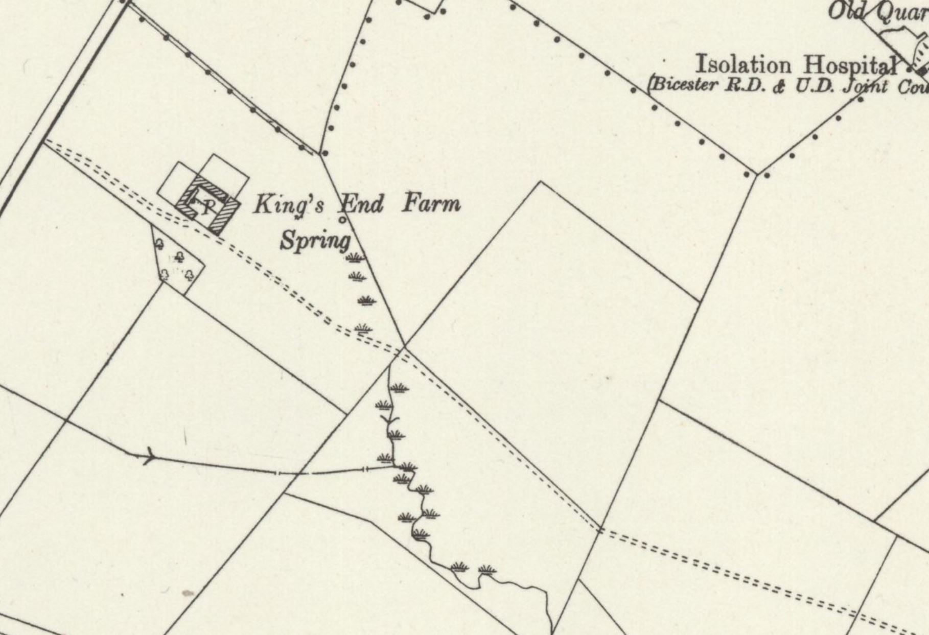
Nothing notable appears to have happened to St Edburg's Well for the next century, apart from the fact that it was evidently used as a water supply at the nearby farm, if not for Bicester itself. Unfortunately, however, the well had fallen into a disrepair yet again by the early 19th century. John Dunkin, in his History and Antiquities of Bicester (1816), wrote that when he visited the well in 1815, "it was nearly choked up with weeds, and the surrounding ground [was] a perfect marsh". This marshy area is shown on the 25-inch OS map of Bicester, dating from 1919.
For reasons unclear, St Edburg's Well was not marked on the 1885 6-inch OS map of the area (although the stream issuing from it was shown), but it was included on subsequent editions as an anonymous "spring". The medieval pathway leading to the well cannot easily be picked out on any of these maps, so presumably it had been ploughed over by then. This "spring" was still marked on OS maps as late as 1970, shortly before the area was covered by a housing estate. Fortunately, there is a possibility that St Edburg's Well survived the building of this development: the exact site of the well is occupied now by a small grassy area in the centre of the estate, full of bushes; it is possible that the spring survives somewhere within the undergrowth.
|
Access: The grassy area in which the well may still be located is publicly accessible. |
Images:
Old OS maps are reproduced with the permission of the National Library of Scotland
Copyright 2025 britishholywells.co.uk