 |
Dedication: none? Location: Sarnau Coordinates: 52.7318N, -3.15224W* Grid reference: SJ222155* Status: destroyed? |
HOME - WALES - MONTGOMERYSHIRE
|
Dedication: none? Location: Sarnau Coordinates: 52.7318N, -3.15224W* Grid reference: SJ222155* Status: destroyed? |
A number of early Welsh saints are associated with the parishes of Meifod and Guilsfield Without, between which Sarnau is split,[1] notably the hermit St Gwyddfarch,[2] his pupil St Tysilio,[3] and St Aelhaiarn, the current patron of Guilsfield's church.[4] St Gwyddfarch, the earliest of the three, is traditionally said to have lived as a hermit on Gallt yr Ancr[2] ("Hill of the Anchor[ite]"), within the parish, and to have founded Meifod's first church;[3] this was probably during the 5th or 6th centuries.[5] As late as 1876, his "rocky sepulchre" on Gallt yr Ancr, which was locally called "Gwely Gwyddfarch" ("Gwyddfarch's Bed" or "Grave"), was "still pointed out to the curious".[6] St Tysilio, a prince of Powys[7] whose medieval cult was evidently very strong in the locality (see Ffynnon Sulien), was apparently one of Gwyddfarch's pupils, and the founder of Meifod's second church.[3] Finally, St Aelhaiarn, the descendant of another prince, reputedly founded a church at Guilsfield during the late 6th century; he is said to have inhabited a place named Llystyn Wennan, located not too far away "in Caereinion".[4] It is possible that one of these three men was originally associated with the site, although I have found no record of the well ever having possessed a patron saint.
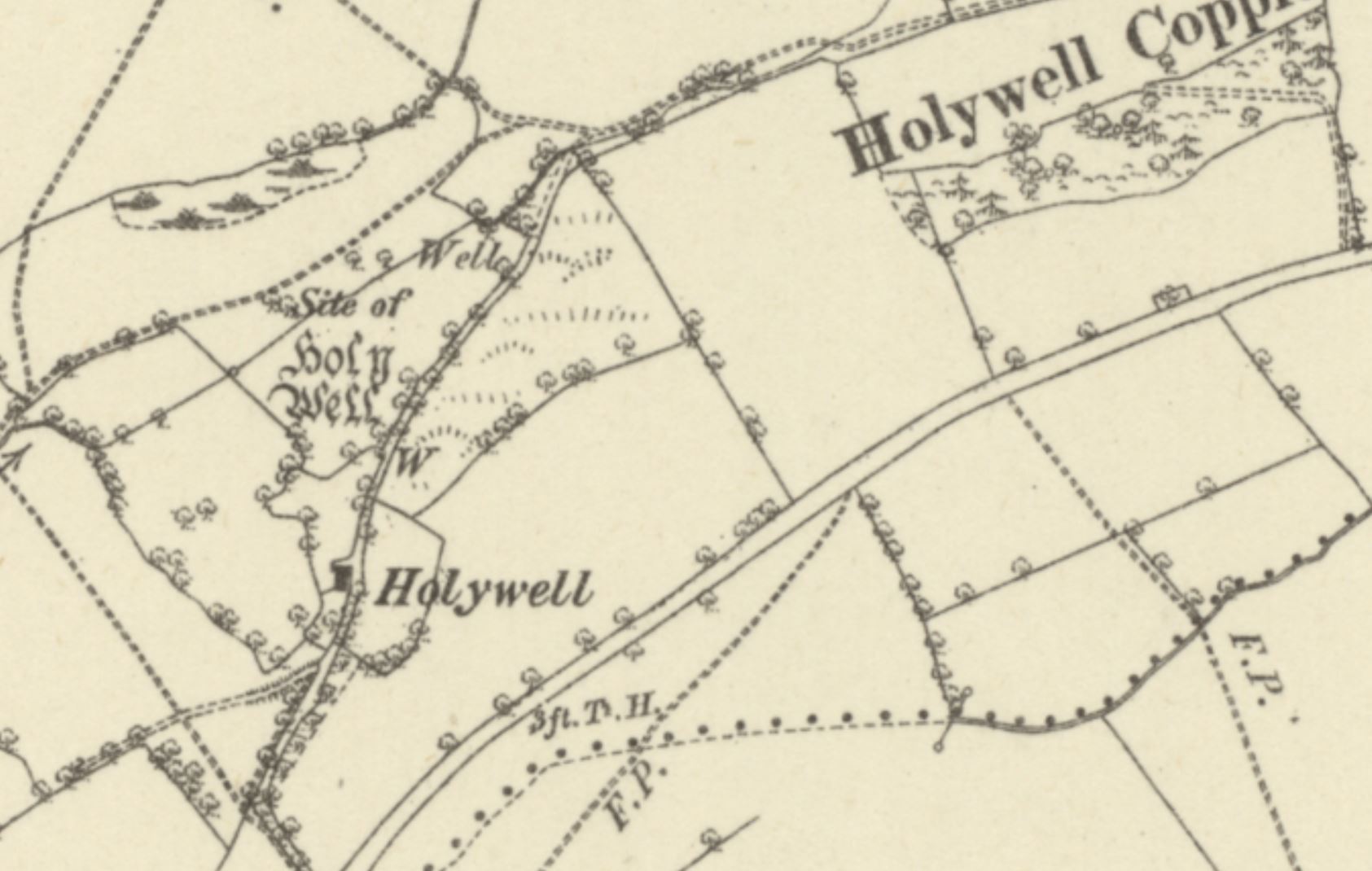
In fact, comparatively few records of the well exist at all, and the earliest reference that I have found to it dates from 1841, when the parish tithe schedule, which mentions a number of plots of land nearby that contain "Hollywell" [sic] within their names, was drawn up. Perhaps most notable are a group of fields all named "Hollywell Meadow", although the name of a small cottage located near the well is also recorded as "Hollywell Cottage and Garden", the words "Holly Well" appearing next to it on the tithe map itself. What is particularly interesting is the fact that "Hollywell" appears to have been regarded (at least by the 1840s) as a place or area in its own right, because the apportionment reports on several pieces of land, none of which are located particularly close to the Holy Well, with names such as "Land near Hollywell" and "Field near Building at Hollywell". It is also interesting to note that the field in which the Holy Well is situated, assuming that the location given for it by historic Ordnance Survey maps[8] is accurate, is called "The Bank", a name which, unlike those of other fields in the vicinity, bears no reference to the site.[9] This suggests that either the location provided by historic OS maps is inaccurate, or perhaps that the well had lost most of its importance by the 1840s, its name then being applied to the area as a whole, causing nearby fields to take on its title, albeit in the slightly garbled form "Holly Well".
Nevertheless, the Holy Well's whereabouts were apparently still known locally in the early 20th century, when the Royal Commission inspected it in 1910. According to the inspecting officer's subsequent report, the site was then under the ownership of "Lord Harlech, Brongyntyn, Oswestry", and was still known variously as "Hali well" and "Holy well", although no mention is made of the form "Hollywell". Unfortunately, the Royal Commission did not provide a particularly detailed account of the well's condition, simply recording that it was a "spring" that had "fallen into disuse", along with "the cottage to which it gave its name".[10] Apart from this, old Ordnance Survey maps, and the indirect reference to the site made by the tithe schedule, the only other vaguely historical reference that I have found to the well dates from 1954, when Francis Jones very briefly mentioned a holy well "near Sarney" [sic] in his Holy Wells of Wales.[11]
Only one point regarding the Holy Well at Sarnau is problematic: all historic Ordnance Survey maps, from 1884 onwards, show the "site of" the Holy Well,[9] [12] [13] but the Royal Commission's report, dating from 1910, suggests that it was then still in existence.[10] A strikingly similar issue has occurred with regards to Ffynnon Gower in Merionethshire, which the Royal Commission found was still in use almost thirty years after Ordnance Survey maps had incorrectly designated it destroyed.[14] [15] The same may well have happened here, although OS surveyors found nothing at the site in 1973,[16] so perhaps by then it truly had been destroyed. There are, therefore, several possibilities: the well may have been destroyed prior to 1884, and the Royal Commission were mistaken, or the Ordnance Survey maps may have been mistaken, and the Royal Commission were correct. Either way, it seems very likely that the two were looking at different locations; in fact, historic Ordnance Survey maps show that several unnamed wells existed in the vicinity,[9] [12] [13] so perhaps the Royal Commission were actually incorrectly inspecting one of these.
I visited Sarnau myself in June 2025, with the aim of solving this problem. However, I was at first thwarted by a blocked footpath and several fields of aggressive cows, and then prevented from approaching the location from a different direction by a mature hedge, which had been allowed to grow over the footpath and was followed by several rows of barbed wire and by more aggressive cows. For these reasons, access to the well, or its site, was unfortunately rendered impossible at the time.
|
Access: Although a public footpath runs right beside the well, it is not the easiest of footpaths to use, and I would not recommend visiting when the cows are on the fields. |
References and footnotes:
*This is the location given by historic Ordnance Survey maps
Images:
Old OS maps are reproduced with the permission of the National Library of Scotland
Copyright 2025 britishholywells.co.uk