 |
 |
HOME - WALES - DENBIGHSHIRE
Dedication: Saint Dunawd? Location: (near?) Hopyard Coppice Status: lost |
Bangor-on-Dee was once associated with the cults of a number of early medieval saints: St Dunawd, who founded a monastery here in the late 6th century, and his three sons, St Deiniol, St Cynwyl and St Gwarthan. According to Sabine Baring-Gould and John Fisher, writing in 1908 in the second volume of The Lives of the British Saints, Dunawd was originally a "chieftain in North Britain", who, being forced by the Picts to flee to Wales for safety, "embraced the religious life". Dunawd reputedly gained the support and protection of Cyngen, then Prince of Powys, who subsequently granted him a portion of land "on the banks of the Dee", for the establishment of a religious community. Traditionally, it is said that Dunawd was aided in this task by his three sons, Deiniol, Cynwyl and Gwarthan, although they later went their own ways, and it was their father who became the monastery's first abbot. This is reflected in the fact that the local church is dedicated, and has been since at least 1852, according to the Rev. Robert Williams' Enwogion Cymru (1852), to St Dunawd, whose cult appears to have been the most dominant in the parish.
Nevertheless, the medieval cult of at least one of his sons, St Deiniol, must have had a presence in the area during the medieval period, because a well under his patronage, now lost, once existed in the parish. This was clearly not, however, Ffynnon y Saint, as the Royal Commission reported in the early 20th century that it had been situated "in the manor of Pickhill and Sesswick", whilst Ffynnon y Saint was located in Royton.
As Ffynnon y Saint almost undoubtedly lost its dedication during the medieval period, there is a very high likelihood that it was originally under the patronage of either St Dunawd, or one of his sons. For the reason stated above, it was almost certainly not Deiniol (the existence of a second well in the parish dedicated to the same saint is very improbable), which leaves Dunawd, Cynwyl or Gwarthan. As Dunawd's cult was evidently the strongest in the parish, Ffynnon y Saint is most likely to have been dedicated to him: it would be strange for St Deiniol to possess a well in the parish, but for his father, patron saint of the church, not to. Of course, there is still a chance that it could have been dedicated to either Cynwyl or Gwarthan.
Regarding Ffynnon y Saint itself, I have been unable to find any information except for facts relating to its location; perhaps any traditions associated with the spring were lost when its dedication was forgotten. Indeed, even as early as 1698, when two references to the well were collected by Edward Lhuyd in his Parochialia, the site's patronage was seemingly unknown. In his Parochialia, within a list of wells within Bangor-on-Dee parish, Lhuyd included "F. y Saint", but wrote nothing more of it. In fact, it is Parochialia's second reference to the spring that is the most useful, when mention is made of "Pont garreg over a stream coming out of Fynnon [sic] y Saint".
In addition to Lhuyd's mentions of the site, I have found two more interesting pieces of information. The first is a field name recorded on the 1840s tithe schedule for the parish, which provides the name of a field at SJ3710645441 as "Saints [sic] Well Meadow". The second is a set of coordinates given for the "Saints' Well" by the Royal Commission, after they had inspected the spring on the 5th of May, 1911: "lat. 53° 0' 11", long. 2° 56' 15". Unfortunately, although these coordinates place Ffynnon y Saint just outside the border of the field named "Saints Well Meadow", thus making them appear plausible, they cannot be heavily relied upon for accuracy. In the interests of determining how reliable they are, I tested out a number of sets of coordinates given by the Royal Commission for Denbighshire, for wells whose exact locations are known, and found them to be shockingly inaccurate. The Royal Commission's set of coordinates for Ffynnon Degla, for example, are around a hundred metres from the correct location, and the same goes for Ffynnon Dogfan at Llanrheaedr ym Mochnant. In fact, none of the coordinates that I looked at were accurate enough to be useful in any way.
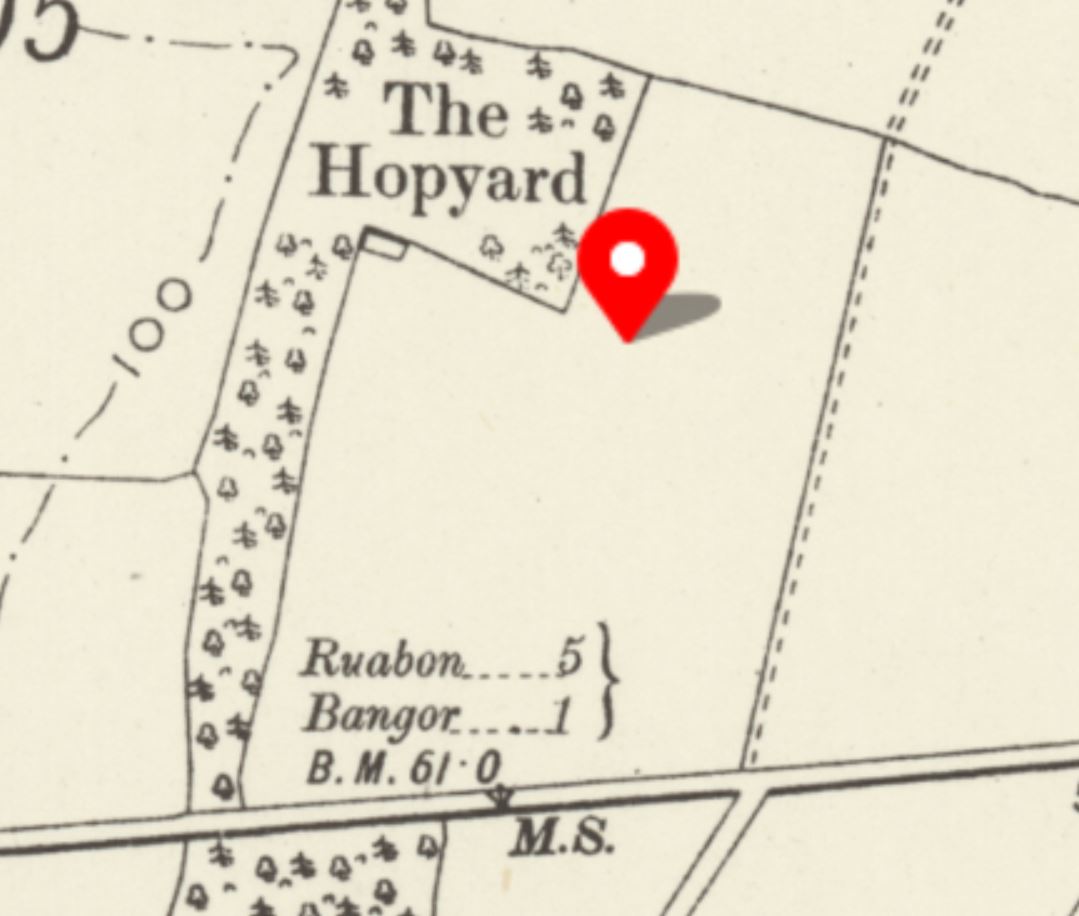
Nonetheless, the Royal Commission's written assertation that the "Saints' Well" is "a spring rising in Hopyard Coppice" (a claim that contradicts the supplied coordinates) is perhaps more reliable, as their written descriptions are rarely flawed. Indeed, "Hopyard Coppice" is located, according to historic OS maps, directly next to "Saints Well Meadow", and flanks both the northern and eastern sides of it. From this, it would appear that Ffynnon y Saint was located somewhere within (if the Royal Commission's description is to be believed) Hopyard Coppice, and thus gave its name to the neighbouring meadow.
However, the situation is somewhat complicated by Edward Lhuyd's description of "Fynnon [sic] y Saint" as feeding a stream that runs under "Pont garreg". Although no historic Ordnance Survey maps mark "Pont garreg", or anything similar, within the bounds of the parish, multiple editions do depict something called "The Stone Bridge" at SJ3555145459, directly on the parish boundary; this is one of the only bridges in the parish. It is surely no coincidence, then, that "Pont garreg" translates, in English, to "Stone Bridge". The bridge at SJ3555145459, therefore, is undoubtedly the one to which Lhuyd's correspondent was referring.
Unfortunately, if "The Stone Bridge" really is the same as "Pont garreg", then this proves rather problematic, as the stream that runs beneath it goes nowhere near Saints Well Meadow or Hopyard Coppice. There is a slight chance that, as the stream passes directly to the south of Royton Farm, to which Saints Well Meadow belongs, water from Ffynnon y Saint would originally have issued into the watercourse somewhere just to the west of the farmhouse. Of course, this is highly unlikely, and does not account for the fact that Lhuyd described the stream as "coming out of" the well, which would suggest that the well was the source of the stream, not just a minor contributor to it. This raises the question of whether there were actually two wells named "Ffynnon y Saint" within the parish, one as the source of the stream under "Pont garreg", and the other "rising in Hopyard Coppice". Indeed, although the actual source of the relevant stream is difficult to pinpoint, a large section of the parish boundary follows it, meaning both that the stream clearly once possessed some local significance, and that its source is situated within Bangor-on-Dee parish. Either way, there was certainly a well named Ffynnon y Saint somewhere in the vicinity of Saints Well Meadow, and perhaps a second, near "Pont garreg".
I visited Royton in October 2025, with the aim of inspecting what remains of Saints Well Meadow, which has now been combined with a number of other fields to create a much larger area, and Hopyard Coppice. I was, unfortunately, unable to gain access to the field, but I did speak to the tenant of Royton Farm, who had no knowledge of the well, or of any water source existing in the field, in particular at the location suggested by the Royal Commission's coordinates. I also spoke to the tenant of Gerwyn-fechan Farm, located to the north of Saints Well Meadow and Hopyard Coppice, who similarly had never heard of the spring, but was able to point me down a dirt track that bordered the other side of Hopyard Coppice. From here, I was able to see that Hopyard Coppice takes the form of an incredibly steep, tree-lined ravine. If Ffynnon y Saint really did, as the Royal Commission wrote, rise "in Hopyard Coppice", then it would have been in a very unaccessible location; perhaps much more likely is that the well was originally situated in Saints Well Meadow, before being diverted into the ravine, to render the field dry and suitable for ploughing.
It is interesting to note that historic Ordnance Survey maps depict a relatively large pool of some description, at SJ3709545522, at the far north-western edge of Saints Well Meadow, bordering Hopyard Coppice; it was labelled as a "pond" on the 1964 OS map of the area. When I visited in October 2025, I was unable to verify whether this still exists or not, but there is a chance that this pond was all that remained of Ffynnon y Saint: Ordnance Survey maps mark it close enough to the edge of the ravine for the Royal Commission to reasonably describe it as being situated "in Hopyard Coppice". Either way, the Historic Environment Record's suggestion that a well marked on OS maps "at SJ 3687 4574", just within Hopyard Coppice, is "an entirely better candidate for Ffynnon y Saint" seems rather unlikely, as this spring is located at such a distance from Saints Well Meadow that the idea that the name of the field is derived from it is almost implausible.
|
|
 |
Copyright 2025 britishholywells.co.uk