 |
Dedication: Saint Mary the Virgin Location: Ffynnon Fair Farm Coordinates: 52.11732N, -4.52743W Grid reference: SN270495 Status: destroyed? |
HOME - WALES - CARDIGANSHIRE
|
Dedication: Saint Mary the Virgin Location: Ffynnon Fair Farm Coordinates: 52.11732N, -4.52743W Grid reference: SN270495 Status: destroyed? |
Very little is known about the history of Ffynnon Fair, mainly because it has not been documented. It is very likely that the well had a direct link with a nearby chapel, although where exactly that may have been located is not easy to determine; perhaps the farm of Ffynnon Fair was built on the site of a medieval chapel after the Reformation, re-using the same building materials. Ffynnon Fair does, however, seem to have given the nearby hill its name, "Bryn-Mair", or "Mary's Hill".
I have only been able to find one reference to the site's existence that predates 1900. It appears in a letter that was written to the editor of Archaeologia Cambrensis on the 29th of November, 1859 by John Fenton, detailing "the substance of some notes I made during a pedestrian ramble in the year 1838":
|
Redundant springs seem to abound in the neighbourhood, and there is one of the same name, Wen, and another, Ffynnon Fair, Mary's Well, a little to the north, between Blaenporth and Aberporth. |
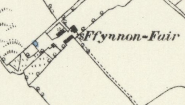
A "spring", which certainly is (or was) Ffynnon Fair, was marked on the eastern side of the farm-yard on the 6-inch 1889 Ordnance Survey map of the area. Although this spring was never marked on later maps, and is not marked on modern OS maps, surveyors occasionally do not include certain sites on modern maps because they have either not been able to find them (as happened at St Chad's Well, Barton upon Humber), or because the well is capped (as happened at the Lady Well, Thornbury, in Herefordshire). For this reason, it is possible that the spring may still exist somewhere in the farmyard.
|
Access: A public footpath runs through the farmyard, going directly past the site of the well. |
Images:
Old OS maps are reproduced with the permission of the National Library of Scotland
Copyright 2025 britishholywells.co.uk