 |
Dedication: Saint Mary the Virgin Location: Uwchmynydd Coordinates: 52.79201, -4.76114 Grid reference: SH139251 Heritage designation: none |
HOME - WALES - CAERNARFONSHIRE
|
Dedication: Saint Mary the Virgin Location: Uwchmynydd Coordinates: 52.79201, -4.76114 Grid reference: SH139251 Heritage designation: none |
Bardsey Island was a major centre of pilrgimage during the medieval era. St Cadfan is said to have founded the first monastery on the island in the 6th century, and from then on it became associated with numerous other famous and popular medieval saints, such as St Derfel, St Dyfrig, and St Maelrhys. Ffynnon Fair, along with its associated medieval chapel, located on the cliffs of the mainland, was the final stop for pilgrims before they reached the island. It is very likely that pilgrims would have visited the well before they began their dangerous journey across the sea in the hope that St Mary would protect them. It is not clear whether the cliff-top chapel was built because of the existence of the well (or visa versa), or whether they were both built at the same time, but they both were certainly constructed for the use of pilgrims.
As it was directly on the pilgrim route, Ffynnon Fair developed several interesting traditions. According to one of these, the spring was visited by St Mary herself, who rode across the sea on a horse and drank of its water. Her handprint, it is said, along with the hoof-print of her horse, can still be seen somewhere on the rocks today. Even after the Reformation, it was asserted that any wish would be granted if the believer could hold the spring water in their mouth without swallowing it whilst clambering back up the cliffs to the chapel and walking around it several times. Before the Reformation, it is possible that it was not wishes that were believed to be granted, but, instead, a safe crossing or a cure from some ailment.
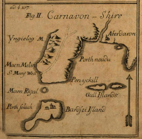
The earliest reference that I have been able to find to the well was made by Johannes Browallius in around 1755 in a Swedish publication entitled Betankande om Vattu-Minskningen. He also wrote about the well at the same time in Hiſtoriſche und Phyſikaliſche Unterſuchung der Vorgegebenen Verminderung des Waſſers und Vergrobsymbolerung der Erde (the map above comes from here), which translates as "Historical and Physical Investigation of the Predicted Reduction of Water and Enlargement of the Earth". Below is a translation of the latter:
|
St. Mary's Well is the name given to a spring of water which lies on the shore on an epic of the mainland. It is situated in such a way that it remains a few feet underwater when the tide is at its highest. However, it starts to become exposed when the sea reaches a medium level between the lowest ebb and highest flood. During an extremely low tide, this water source can be found a good stretch away from the shore, rising above the water surface. More than six hundred years ago, according to the testimony of the history books, the monks had the habit of going in procession to this well at certain times, accompanied by a large gathering of people, according to papal decree. They timed their visits to coincide with the periods when the well became prominently visible during a particularly low tide. The well remains in the same state today as it was then, with water levels rising just as high above it during a flood and receding just as far below it during an ebb as they did centuries ago. The daily difference between the highest and lowest water levels, during normal ebb and flood cycles, is ten to twelve English feet. |
Thomas Pennant, too, made what is probably the most famous reference to the well (if it can be called "famous") in 1778 in A Tour Through Wales:
|
After landing at Aber-daron, I rid to its ſummit, and found the ruins of a ſmall church, called Capel Vair, the Chapel of our Lady; and I was informed, that at the foot of the promontory, below high-water mark, was a fountain of freſh water, to which devotees were wont to deſcend by a circuitous and moſt hazardous path, to get, at low-water, a mouthful of the ſpring; which, if they carried up ſafe to the ſummit, their wiſh, whatſoever it was, was to be ſurely fulfilled. This was under the protection of our Lady, and called Ffynnon Vair. |
It seems that the tradition of holding water in the mouth whilst circling the chapel had pretty much died out by the mid 19th century, perhaps as the chapel was in such bad repair, it having been essentially abandoned since the Reformation. The well, however, was still known of, as were its associated traditions, even if they were not practiced as often they once had been. A Mr T. E. Morris, who made reference to the site at the end of John Rhys' essay Sacred Wells in Wales, which was published in the Folk-lore magazine in 1893, related that he had visited the well, and been well aware of the custom, but had "felt no desire, under the circumstances, to wish". By the late 19th century, when Ordnance Survey maps of the area were first produced, the chapel was marked as "site of".
Ffynnon Fair continued to be visited throughout the 20th century, although much less frequently than it had been in times past. In 1904, a fifteen-year old girl named Joan Abbott Parry either slipped on the rocks or was hit by a wave whilst visiting Ffynnon Fair, and was carried off to sea and drowned. The Solicitor's Journal and Reporter reported the tragic incident:
|
Miss Joan Abbott Parry, the youngest daughter of Judge Parry, of the Manchester County Court, was drowned while bathing on Tuesday at Aberdaron, situated on a bay at the end of the Carnarvonshire peninsula. Miss Parry, who was fifteen years of age, was washed off the rocks into deep water. |
Today, nothing is marked of the chapel on Ordnance Survey maps and very little - if anything - is left of it. Ffynnon Fair, however, still survives on the cliffs, presumably unchanged from its medieval form.
|
Access: This well is perhaps the most dangerous of all sites in Britain to visit, and should be visited with caution at low tide on a dry day. |
Copyright 2025 britishholywells.co.uk