 |
Dedication: Saint Mary the Virgin Location: Dingleton Coordinates: 55.59157, -2.72063* Grid reference: NT546333* Status: lost? |
HOME - SCOTLAND - SCOTTISH BORDERS
|
Dedication: Saint Mary the Virgin Location: Dingleton Coordinates: 55.59157, -2.72063* Grid reference: NT546333* Status: lost? |
Although very little is recorded regarding the history of St Mary's Well at Dingleton, there is a high possibility that it was originally connected in some way to Melrose Abbey, which itself was dedicated to St Mary, and was founded, according to the 21st edition of Black's Picturesque Tourist of Scotland (1877), in 1136. In fact, James A. Wade wrote in 1861, in his History of St. Mary's Abbey, Melrose, that "several Springs" in Dingleton, located near "the Locked Well", once constituted the monastery's water supply, which was brought to the Abbey "by Leaden Pipes". Intriguingly, Historic Ordnance Survey maps show that what they call the "Locket Well" was situated at NT5468733564, in very close proximity to the spring now marked as "St Mary's Well", which may well have been one of the springs that Wade was referring to. Perhaps St Mary's Well gained its title because of its practical uses for the Abbey; the dedication of a religious community's water supply to a saint appears to have been quite a common practice at the time.
Irrespective of its probable medieval importance, the earliest reference that I have found to St Mary's Well dates from 1845, when it was mentioned by the Rev. George Thomson, in The New Statistical Account of Scotland (unfortunately, no reference to the spring appears in the Old Statistical Account). Thomson included a well called "St Mary's" in a list of "principal springs" which "still retain the names of Romish saints", but did not provide any more information about it, or its location within the parish. The same can be said about a reference to a well of "Our Lady" at "Melrose" that was published in the journal of the Society of Antiquaries of Scotland in 1883, as part of a "List of 'Holy Wells' in Scotland".
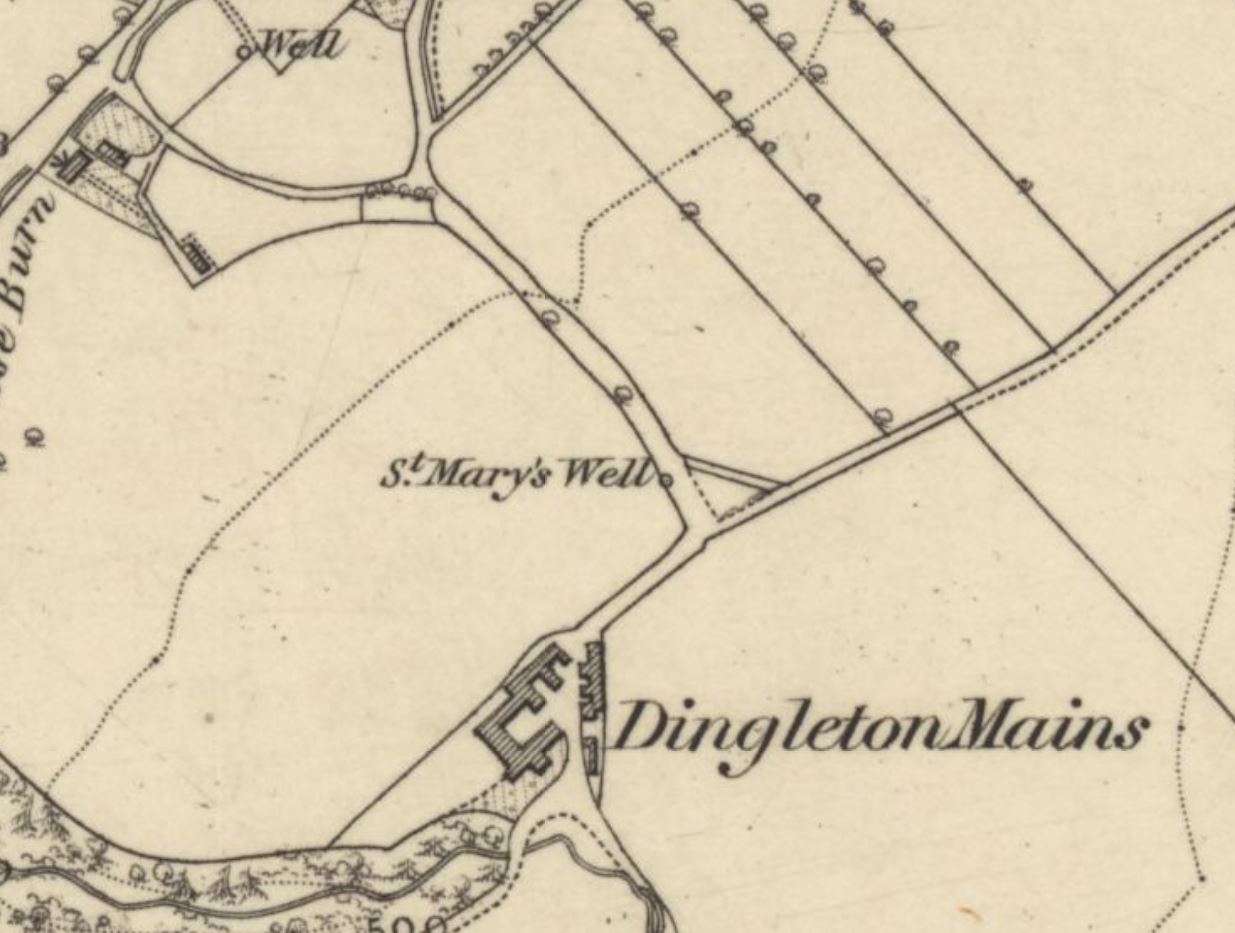
In fact, only historic Ordnance Survey maps provide the location of St Mary's Well, which has been marked and named at NT5468033340 on every OS map published of the area. It is interesting to note that the 1863 6-inch OS map of Dingleton depicts what appears to be a small road or track running south past St Mary's Well, to Dingleton Mains, the farm on which this particular spring is located. This is confirmed, a century later, by the 1964 OS map, which describes this as a "track", named, according to the 1898 25-inch, "Dingleton Loan".
However, the situation is not so straightforward, as a statement published in the Ordnance Survey Name-Book, in 1859, severely complicates the matter of the site's location:
|
Although called St Mary's Well, there is no authority for saying it was ever consecrated, nor is there a certainty that this is really the well called "St Mary's", but the local authorities consulted wish to retain the historical and traditional name and have given it to this well. |
If the spring at NT5468033340 actually is not the true St Mary's Well, then it is impossible to tell where exactly it was really situated. Nevertheless, a good chance remains that this water source is the authentic site, and, even if it was not, then its surviving structure certainly implies that it once possessed some local importance.
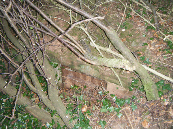
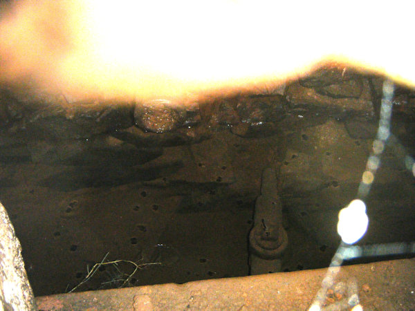
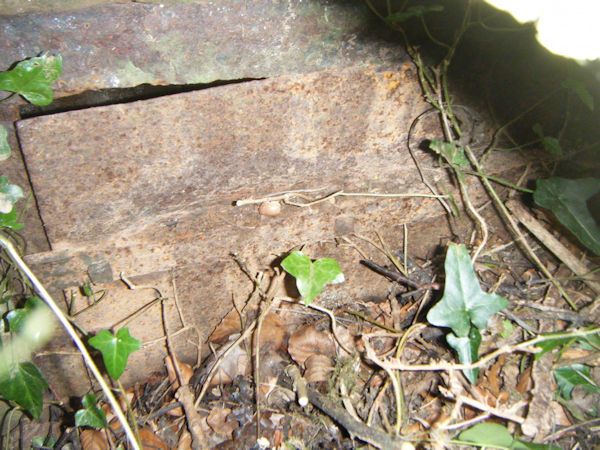
When I visited the spring at NT5468033340 in July 2025, I found that quite a substantial structure, of an unclear date, but almost certainly not medieval, still existed at the site. Although it was partially buried beneath a very large quantity of soil, and hidden in what can only be described as a large bush, I was able to distinguish a roughly square building, perhaps once a metre in height (although it was difficult to tell) and the same in width, constructed of cut stone blocks. Access to the water was clearly originally through a metal door, now rusted and obstructed by the soil. This door was open a crack, but I was unable to get a good look inside the structure. After inspecting the site, I spoke to one of the owners of Dingleton Mains, who had never heard of the spring, and was unaware of its existence. The main image for this page is a view of this structure.
 |
 |
 |
|
Access: The structure at NT5468033340 is located beside a path (Dingleton Loan), and is accessible from a number of angles. |
*This is the location of the spring that OS maps describe as "St Mary's Well"; whether this really is the holy well is impossible to prove.
Images:
Old OS maps are reproduced with the permission of the National Library of Scotland
Copyright 2025 britishholywells.co.uk