 |
Dedication: Saint Mary Location: Commore Coordinates: 55.76332N, -4.45537W Grid reference: NS460549 Heritage designation: none |
HOME - SCOTLAND - RENFREWSHIRE
|
Dedication: Saint Mary Location: Commore Coordinates: 55.76332N, -4.45537W Grid reference: NS460549 Heritage designation: none |
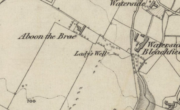
Absolutely nothing is known of the Lady Well's early history, although it is believed to have had a link to a medieval chapel that is said to have stood nearby. It is not to be confused with the parish's most prolific spring, known as the "Aboon-the-Brae", which was once famous for producing 42 gallons of water per minute; in comparison, the Lady Well is one of the most poorly documented holy wells in Scotland. I have been unable to find out any information about its history, apart from that which is included on the Canmore database.
Nonetheless, the well was both named and marked on most Ordnance Survey maps, and it still continues to be marked as a well today. The site was visited on the 6th of July, 2007, by RCAHMS, who described it as a "brick-built cistern":
|
This well is situated at the foot of a steep ESE-facing slope 120m ESE of Aboon the Brae farmsteading. It comprises a square, brick-built cistern that collects water from a natural spring and its sides are surmounted by chamfered sandstone copes. The well lies within stone walled enclosure, the SE side of which, adjacent to the well, has collapsed outwards. There is an iron gate into the enclosure on the NNE. |
Today, judging by its continued inclusion on Ordnance Survey maps, it appears that the well's condition has not changed at all since 2007.
|
Access: The Lady Well is located on private land. |
Images:
Old OS maps are reproduced with the permission of the National Library of Scotland
Copyright 2025 britishholywells.co.uk