 |
Dedication: Saint Beathag Location: Tarbert Coordinates: 55.70373N, -5.73164W Grid reference: NR656518 Heritage designation: none |
|
Dedication: Saint Beathag Location: Tarbert Coordinates: 55.70373N, -5.73164W Grid reference: NR656518 Heritage designation: none |
Very little is known about Beathag, a local saint who perhaps spent time as a hermit on the island. It is possible that she was the same as the 13th century prioress of Iona, Beathag, but it is probably unlikely. Nonetheless, this well was certainly associated with this minor saint's local medieval cult.
The earliest known reference to St Beathag's Well appeared in 1695, in Martin Martin's Description of the Western Isles. Although Martin referred to the site as "Toubir-more", or "a great Well", it is clear that he was describing St Beathag's Well. Martin noted that all of the inhabitants of the Isle were Protestant, and, so soon after the Reformation, it is possible that a more secular name for the well had come into use. Martin describes it thus:
|
THERE is a Well in the North End of this Iſle ["Gigay"] called Toubir-more, i.e. a great Well, becauſe of its Effects, for which it is famous among the Iſlanders; who together with the Inhabitants uſe it as a Catholicon for Diſeaſes. It's cover'd with Stone and Clay, becauſe the Natives fancy that the Stream that flows from it might overflow the Iſle; and it is always opened by a Diroch, i. e. an Inmate, elſe they think it would not exert its Virtues. They aſcribe one very extraordinary Effect to it, and 'tis this; That when any Foreign Boats are Wind bound here (which often happens) the Maſter of the Boat ordinarily gives the Native that lets the Water run, a Piece of Money; and they ſay, that immediately afterwards the Wind changes in favour of thoſe that are thus detain'd by contrary Winds. Every Stranger that goes to drink of the Water of this Well, is accuſtomed to leave on its Stone-Cover a Piece of Money, a Needle, Pin, or one of the prettieſt variegated Stones they can find. |
The unusual power that the well was supposed to have had over the wind was still remembered by the 19th century, although it does not seem to have been used very often by that time. Locally, it was said that the well had once been used to prevent excise officers from reaching the island, by changing the wind. A century after Martin's account, the heap of stones or offerings was still visible covering the well, as described in 1796 in Encyclopaedia Perthensis:
|
Of this wonderful well, Mr Fraſer, miniſter of Gigha and Cara, gives the following account: "It is ſituated at the foot of a hill fronting the NE. near an iſthmus called Tarbat. Six feet above where the water guſhes out, there is a heap of ſtone, which forms a cover to the ſacred font. When a perſon wiſhed for a fair wind, either to leave the iſland, or to bring home his abſent friends, this part was opened with great ſolemnity, the ſtones carefully removed, and the well cleaned with a wooden diſh or clam ſhell. This being done, the water was ſeveral times thrown in the direction (or art,) from which the wiſhed for wind was to blow, and this action was accompanied with a certain form of words, which the perſon repeated every time he threw the water. When the ceremony was over, the well was again carefully ſhut up to prevent fatal conſequences; it being firmly believed, that, were the place left open, it would occaſion a ſtorm, which would overwhelm the whole iſland. This ceremony of cleaning the well, as it is called, is now ſeldom or never performed; though ſtill there are two old women, of the names Galbreath and Graham, who are ſaid to have the ſecret, but who have cauſe to lament the infidelity of the age, as they derive little emolument from their profeſſion." |
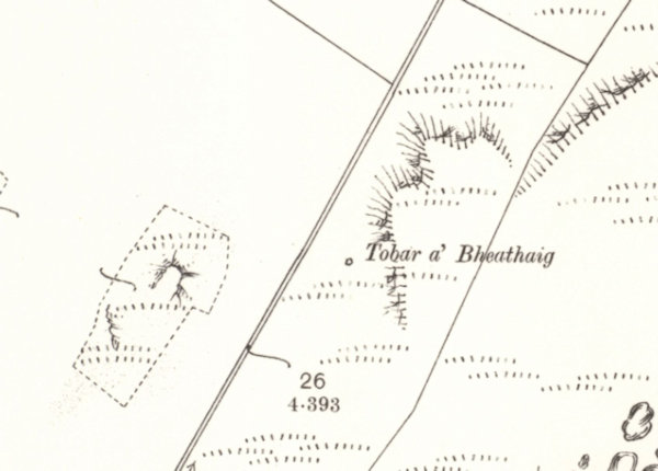
By 1978, however, this heap of stones or offerings had completely disappeared; according to surveyors, it was nothing more than "an oval shaped, shallow spring in the foot of a vertical slope", measuring "0.5m by 0.7m". Most importantly, they noted that there was "no sign of a heap of stones". Today, the current condition of St Beathag's Well is not known, although it certainly still exists.
|
Access: The well is located on private land. |
Images:
Old OS maps are reproduced with the permission of the National Library of Scotland
Copyright 2025 britishholywells.co.uk