 |
Dedication: none Location: Beltoft Coordinates: 53.55108N, -0.7829W Grid reference: SE807067 Status: uncertain Heritage designation: none |
HOME - ENGLAND - LINCOLNSHIRE
|
Dedication: none Location: Beltoft Coordinates: 53.55108N, -0.7829W Grid reference: SE807067 Status: uncertain Heritage designation: none |
Nothing is known regarding the early history of Beltoft's holy well, although it undoubtedly dates from the medieval period, and perhaps from even earlier. Nonetheless, the earliest reference that I have found to the site dates from 1795, when the Inclosure Act designated the well as being exempt from being enclosed, or tampered with in any way:
|
Provided always, That nothing in this Act contained ſhall extend or be conſtrued to extend to impower the ſaid Commiſſioners, or any of them, to allot or divert a certain Spring or Well of Water, in a certain Lane, within that Part of the ſaid Commons adjoining to and coming from the South Moor to the Hamlet of Beltoft, in the Pariſh of Belton aforeſaid, called Holy Well or Halliwell, or to allot the ſame to any One or more Proprietors or Proprietor, within the ſaid ſeveral Pariſhes, or any of them, but that the ſame Well and Spring ſhall fore ever hereafter remain in its preſent unincloſed State, for the free Uſe and Enjoyment of all and every the ſaid Proprietors, without any Interruption whatſoever. |
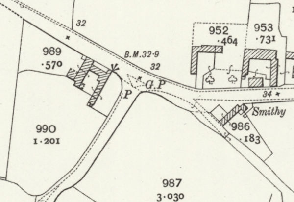
Clearly, the Holy Well was of great local importance, and must have been the village's main water supply. In fact, historic Ordnance Survey maps show that the site was fitted with a pump and stone trough as early as 1885. Despite its past importance, however, it is one of the least well-known sites in England, and the only other historical reference to the Holy Well that I have come across appears in Thomas Benjamin Franklin Eminson's Place and River Names of the West Riding of Lindsey, Lincolnshire (1934); unfortunately, this only quotes a small portion of the Inclosure Act (as seen above), and provides no further information regarding its history.
I was recently contacted by a previous tenant of Holywell Farm, the house located just in front of the well, who kindly informed me both of the site's existence and that the spring was diverted by the council, in the 1970s, into a watercourse running beside the road; after this, the trough reportedly vanished. What has become of the site today is uncertain, and modern Ordnance Survey maps, which now call the house "Holly Well Farm", fail to indicate whether anything still exists at the spring's site.
|
Access: The site of the trough and pump is located at the side of a public road. |
Images:
Old OS maps are reproduced with the permission of the National Library of Scotland
Copyright 2025 britishholywells.co.uk