 |
Dedication: Saint Chad Location: Barton upon Humber Coordinates: 53.692060N, -0.469625W Grid reference: TA011228 Heritage designation: none |
HOME - ENGLAND - LINCOLNSHIRE
|
Dedication: Saint Chad Location: Barton upon Humber Coordinates: 53.692060N, -0.469625W Grid reference: TA011228 Heritage designation: none |
St Chad, the bishop of Lichfield and the second abbot of his late brother's monastery at Lastingham, was granted land at Barrow upon Humber (which is only two miles or so away from the well) by King Wulfhere of Mercia, who ordered Chad to found a monastery there, and to extend his Christian mission. It is very probable that St Chad himself visited the site of the well; he is known to have spent some time in Barton upon Humber (he is said to have baptised new converts in a pool of water outside St Peter's Church that is known as "The Beck" or "St Chad's Well"), and it appears that he worked as a missionary in the area.
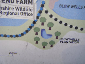
St Chad's Well (not The Beck) is located in a small spinney that is known known as the "Blow Wells Plantation". This name is rather recent, and records show that it was originally known as the Shad Wells, which is doubtlessly a corruption of "St Chad's Wells". The site was mentioned in a 13th century charter, which made reference to "stagnum molendini de Scadewell", which translates as "the pond of the mill of Shadwell". Another reference to the site can be found in part of the Bardney Cartulary, in which "Schadewelle" is mentioned in a document that refers to land at Barton upon Humber. The Bardney Cartulary is a collection of early medieval documents that was compiled in the late 13th century. It is of course possible that the springs were originally "Shady Wells", but the area's link to St Chad and the existence of a chapel next to the site indicate otherwise. It is not clear why the plantation's name changed from "Shad Wells" to "Blow Wells", but it appears to have occured after the Reformation. Henry William Ball, in his Social History and Antiquities of Barton-upon-Humber (1856), wrote briefly about the site:
|
To the west of Barton are deep springs of flowing water, called blow wells, and in the old town's book they are designated "the Shadwells," and the head of the brook "Bradwell." The water from these springs was sufficient in former days to supply the water mill at the top of the haven. |
It appears that St Chad's Well was, in the medieval period, connected to a small chapel or church. In 1867, the remains of what appeared to be a small chapel were unearthed in a field just south of the Shad Wells, at TA01112270, directly next to the plantation. Robert Brown, writing in Notes on the Earlier History of Barton-upon-Humber in 1906, described the discovery:
|
The Shad Wells are now commonly called the Blow Wells, and in the Stamford Mercury of March 22, 1807 [this should be 1867], it is recorded that men then recently digging in a field on the south side of the Blow Wells exposed 'several large worked stones, finely cut and faced,' and 'an old window made of lead with wire bars, and the remains of what looked like coloured glass.' They also found 'a number of stones which appeared to have formed a foundation of a greyish character.' These remains appear to indicate that at one time a small hermitage or chapel existed in Schadewelle Dale. |
It was common in the medieval era for small chapels such as the one that existed near the Shad Wells to have an associated well, both of the same dedication. These wells provided water for baptisms; St Chad's Well was probably used for the same. It is likely that the chapel was dedicated to St Chad, and it is possible that he founded it himself. Whilst it is unclear why exactly the chapel was either abandoned or destroyed, it probably happened as a result of the Reformation. Today, no trace of this chapel can be seen, and the carved stonework that was found is probably now gracing someone's rockery.
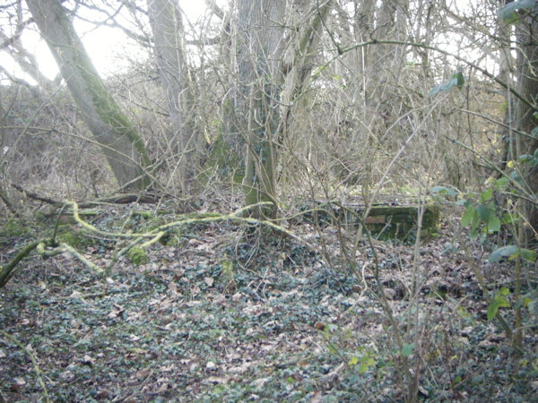
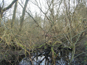
Today, the so-called "Blow Wells Plantation" is part of Far Ings National Nature Reserve. The original St Chad's Well appears to have been capped (the image above is of two capped springs that can be seen on the edge of the plantation - one, or both, of them must be St Chad's Well), and it is not clear where its water is piped off to, although it is possible that the well feeds the body of water that exists inside the plantation. It is worth noting that the Lincolnshire Historic Environment Record is incorrect in its statement that St Chad's Well no longer exists. The site has always been named on Ordnance Survey maps as the "Blow Wells Plantation", but St Chad's Well has never been named on maps, as the OS surveyors were looking in the wrong place for it (according to the Historic Environment Record, they were looking for the spring in a ploughed field).
 |
 |
|
Access: A public footpath runs beside the north and west sides of the plantation. When I visited in the December of 2024, the capped springs could be seen through a gap in the hedge; it may be more overgrown in the summer months, so they may not be visible. The map and coordinates represent the approximate location of the capped springs. |
Copyright 2025 britishholywells.co.uk