 |
Dedication: Saint Chad Location: Twyning Coordinates: 52.023900N, -2.141744W Grid reference: SO903361 Heritage designation: none |
HOME - ENGLAND - GLOUCESTERSHIRE
|
Dedication: Saint Chad Location: Twyning Coordinates: 52.023900N, -2.141744W Grid reference: SO903361 Heritage designation: none |
Very little is known about Twyning's holy well, which has always been named on Ordnance Survey maps as "Chad Well". Legend has it that St Chad himself blessed the well on his way to Bristol, although there does not appear to be any record of St Chad actually travelling to Bristol at any point in his lifetime. The well did not get its name from the local church, which is dedicated to St Mary Magdalene, and I am therefore unfortunately left with the conclusion that this well is probably one of those that was originally simply a "cold well" which became, through corruption of the name, dedicated to St Chad. In several cases across the country, the Old English "caldewelle" (cold well) has over time been transformed into "Chad Well", which accounts for the numerous "St Chad's Wells" that can be found in areas that St Chad is never supposed to have visited. It must, however, be noted that there are no known records of the name of Twyning's holy well until well after the Reformation, by which time it had attained the name "Chad Well", so it is impossible to tell whether the same applies in this case or not. Alternatively, as Chad was such a popular saint in the early medieval period, is is possible that the well became dedicated to him simply through his major popularity.
A very minimal amount has been written or recorded about St Chad's Well, and most - if not all - of the records that do exist about the site date from the 20th century. Indeed, Lindsall Richardson, on a field trip to the Chad Well by the Cotteswold Naturalists' Field Club in 1926, is quoted as stating:
|
This well is marked on the Ordnance Survey Map as an ancient well, but I have not been successful in finding any reference to it in literature. |
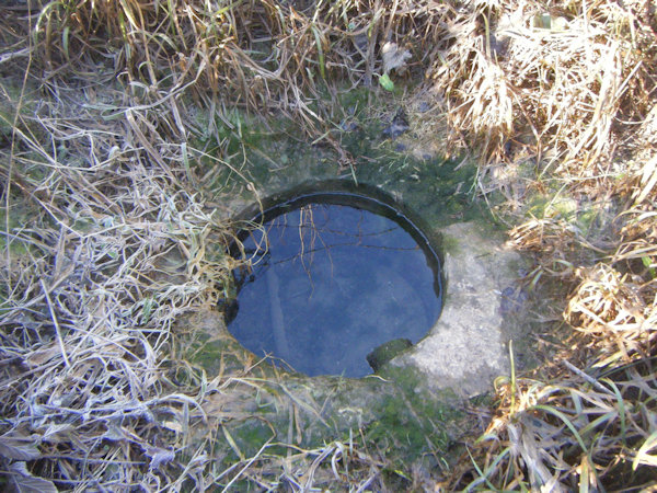
Despite the fact that the well may never have had a direct link to St Chad, it was evidently important at some point, as quite a substantial stone surround was constructed around the spring at some point in its history. Whether the structure is Victorian or is much older - possibly even medieval - is not clear.
Today, the well can be seen beside the River Avon, surrounded by a barbed wire fence. At the time of my visit (January 2025), the well appeared to be in good condition. The spring was producing a large quantity of fresh water, which was carried under the footpath through what looked like a clay pipe, and left to issue into the River Avon.
|
Access: A public footpath runs right beside the well, although, as the site is located so close to the banks of the Avon, it is liable to flooding and may not always be accessible. |
Copyright 2025 britishholywells.co.uk