 |
Dedication: Saint Thomas the ? Location: Repton Coordinates: 52.84089N, -1.55709W Grid reference: SK299271 Status: destroyed |
HOME - ENGLAND - DERBYSHIRE
|
Dedication: Saint Thomas the ? Location: Repton Coordinates: 52.84089N, -1.55709W Grid reference: SK299271 Status: destroyed |
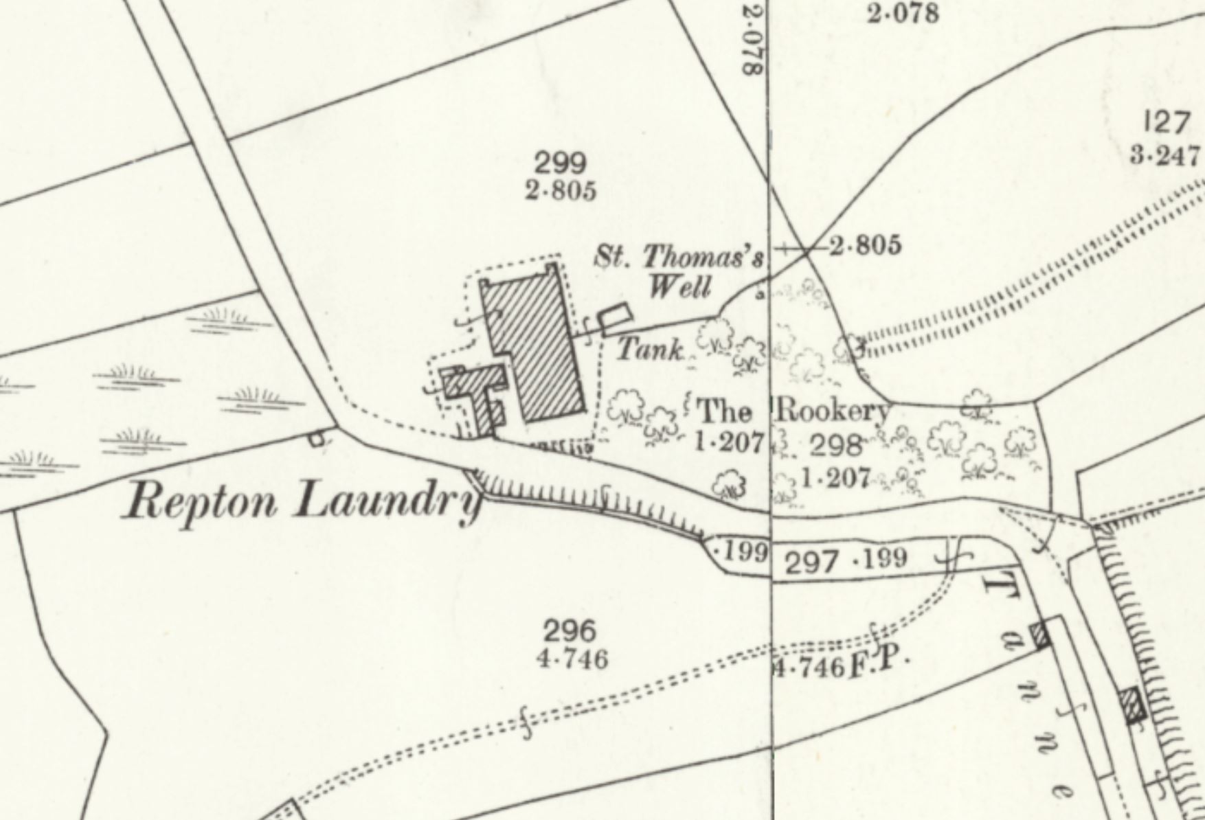
Although it is not clear which St Thomas this holy well was, historically, dedicated to, it is evident that the spring got its name from an association with Repton Priory. The priory was founded in 1153, as an Augustinian establishment, and placed under the governence of nearby Calke Priory. Despite its somewhat lowly status, the institution was one of Derbyshire's most popular destinations for pilgrims, boasting the famed shrine of St Guthlac, and several chapels dedicated to a variety of saintly figures. Amongst these assorted chapels was, according to Robert Bigsby, writing in his Historical and Topographical Description of Repton (1854), a chapel of St Thomas, the existence of which was recorded at the dissolution of the priory in around 1538. Whilst this may simply be a coincidence, owing to the fact that St Thomas was a popular medieval dedication, it does establish a possible link between the priory and the well, and the record is suitably ambiguous to allow for speculation: it is plausible, and indeed quite probable, that this "chapel of St Thomas" was actually a medieval well-chapel, located directly over St Thomas' Well.
In fact, there can be no doubt that the well was created by the prior or monks for the purpose of attracting yet more pilgrims. Bigsby asserted that the site was once believed to be "efficacious in certain disorders of the eye", which is probably a surviving medieval tradition. Apart from this, however, no other details of the well's veneration are recorded.
St Thomas' Well was evidently also linked to the nearby surviving well of St Ann, perhaps forming a sort of miniature pilgrimage route from the priory to both holy springs. Intriguingly, St Ann's Well is still connected to the site of the priory by an existing footpath, half-way along which St Thomas' Well was located, suggesting that there was once a well-established route leading from the priory to both holy wells. In fact, the field in which both wells were once located is called, according to the tithe schedule "The Holy Wells", which indicates that the two were closely linked and perhaps venerated in conjunction with each other.
It is not obvious whether the well continued to be used for religious purposes following the Reformation and the cessation of pilgrimage to Repton, but it was definitely used as a practical water supply for several centuries, until its unfortunate destruction at some point in the last few decades. The site still existed when a Historic Environment Record field observation was carried out in 1966, and it was marked as a "well" on the 1969 OS map of Repton, but it was utterly destroyed, along with whatever structure it possessed, when a new sports pitch was created by Repton School.
Images:
Old OS maps are reproduced with the permission of the National Library of Scotland
Copyright 2025 britishholywells.co.uk