 |
Dedication: Saint Bega Location: St Bees Coordinates: 54.50277N, -3.58423W Grid reference: NX975130 Status: Unknown |
HOME - ENGLAND - CUMBERLAND
|
Dedication: Saint Bega Location: St Bees Coordinates: 54.50277N, -3.58423W Grid reference: NX975130 Status: Unknown |
St Bega was an early saint from the kingdom of Northumbria. Her time of life is not known for certain, but it is probable that she lived during either the 7th or 8th century. According to tradition, Bega was the daughter of an Irish king, and, as she was the most beautiful woman in the entire country, the King of Norway's son asked for her hand in marriage. Bega, however, had already vowed that she would be a virgin: as a confirmation of this pledge, an angel gave her a bracelet that was marked with the sign of the cross. In a desparate attempt to escape this proposed marriage, she is said to have sailed across the Irish Sea to St Bees, where she lived in seclusion. Bega is believed to have travelled to Northumbria to avoid the Viking raids that were sweeping the coastline at the time, leaving only her bracelet behind. This bracelet, or, at least, something resembling it, was on show in the local priory from at least the 12th century onwards; oaths were often sworn upon it, which not only shows the relic's importance in Bega's cult, but is surely also symbolic of the oath that Bega herself is said to have sworn, which indicates that this legend was already in circulation shortly after her death. In the early 13th century, Robert de Vipont and his wife gave ten shillings (£450 today) to "God and the church of St Mary the Virgin in which the bracelet was kept" as rent, and, in 1279, Eda, the daughter of Ivo the smith of Ravenglass, took an oath "upon the bracelet".
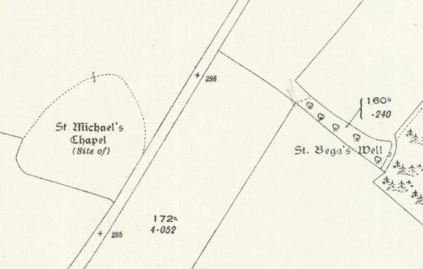
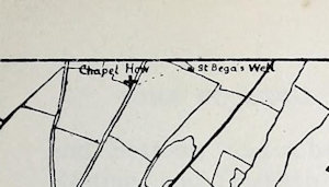
Very little is known of the medieval history of St Bega's Well, although it certainly had some significance in the community, and people were once accustomed to, according to the Historic Environment Record (which, it must be noted, is often untrustworthy), "drop pins and other small objects into it". The site probably had a link to St Michael's Chapel, which was located only a few hundred metres from the well, and may have been a stopping point for pilgrims on their way to St Bees. The well, unfortunately, managed to escape any form of documentation until the early 20th century. The earliest reference to the site that I have been able to find dates from 1909, and can be found in volume 9 of a publication entitled Transactions of the Cumberland & Westmorland Antiquarian and Archaeological Society:
|
Exactly opposite to Chapel How, and 150 yards east of the road, is St. Bega's Well, with traces of a lane leading down to it. The chapel by the roadside was probably connected with the well one hundred feet lower down the hillside, and a supply of water may have been kept at the chapel for the benefit of wayfarers. |
In the early 19th century, or thereabouts, several "dressed stones" were ploughed up very close to St Bega's Well. Whilst it is probable that this stonework originated from the chapel, it is possible that some of it may have once been part of a structure around St Bega's Well. There is, of course, no documentary evidence for this theory, but there is nothing to disprove it.
St Bega's Well was not named on Ordnance Survey maps until 1923, but a small square shape was marked on the 1863 25-inch OS map of the area, which was almost certainly the well. On an Ordnance Survey map of 1962, the "site of" St Bega's Well was marked; it is not clear whether the well was simply covered, or whether it had been destroyed. Today, the site is no longer marked on OS maps, although it may still exist if it is indeed covered, which is what the Historic Environment Record states. According to a recent field investigation that the HER records, "St. Bega's Well is now blocked and over-grown. All that can be seen are three large moss covered slabs of stone covered by bramble bushes. It is possible that the well is now dry, but this could not be firmly established. No further information on its origin could be ascertained in field investigation". Put simply, the site's condition is not certain.
 |
|
Access: The well is located on private land. |
Images:
Old OS maps are reproduced with the permission of the National Library of Scotland
Copyright 2025 britishholywells.co.uk