 |
 |
 |
Dedication: Saint Germochus Location: Germoe Status: lost |
According to tradition, St Germochus was an Irish king who sailed to Cornwall in the 5th century to spread Christianity. He is reputed to have landed at the mouth of the River Hayle in or around the year 460, and from thence travelled to present-day Germoe, where he founded the parish church. Although the fact that his name does not appear elsewhere in Cornwall suggests that he was more of a hermit than a missionary, the 15th century remarks of William of Worcester, who described Germochus as "St. Gyermock bishop", may imply that the saint actually had considerable influence in the area. After the death of Germochus, his remains were, according to John Leland's early 16th century Itinerary, kept at St Germoe's Church, where his "tumb is yet seene". In addition to Germochus' relics, the church also boasted a mysterious attraction described by Leland as "S. Germoke's chair", and, of course, the holy well. It is worth noting that Leland's work was compiled only shortly before the Reformation.
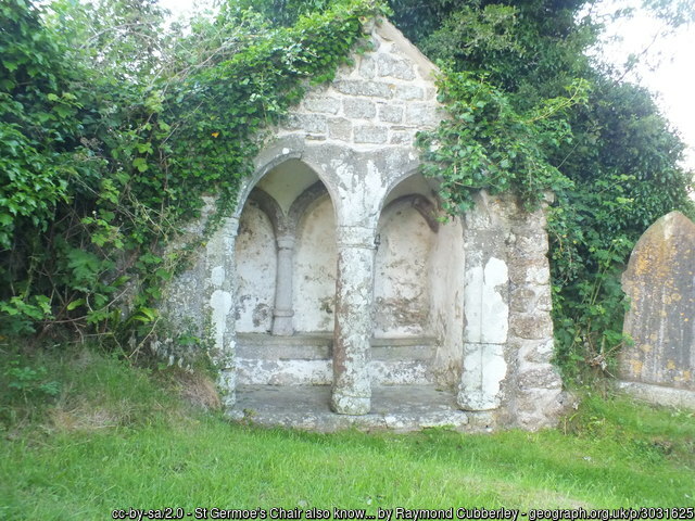
Interestingly, Leland also mentioned "S. Germoke's welle", which he placed "a litle without the chirch-yard". Leland wrote of only a couple of Cornish holy wells in his Itinerary, so St Germoe's was evidently an important site in medieval times. Of course, this fame and importance was clearly damaged by the Reformation, at which time the original St Germoe's Chair was most probably taken down or destroyed.
There are many different theories for the origin of the modern version of St Germoe's Chair, a Grade I listed building, all of them very plausible: some historians suggest that it originally formed part of a sedilia, or that it was simply built as a sort of folly by local landowners. However, the author of a paper entitled Notes on Some of the Churches in the Deaneries of Kerrier and Kenwith, published in The Archaeological Journal in 1861, suggested that it had originally been housing for a holy well, mostly based on the fact that its "form, details, and dimensions are so thoroughly those" of surviving holy wells in Cornwall, although it was impossible to determine whether it was "in situ", or had been "removed from another place". It is quite possible that this structure did originally house a medieval holy well, and, assuming that it did, that holy well would almost certainly have been St Germoe's. Furthermore, the elaborate construction of this building would align with the importance that the well obviously had in the medieval period. Of course, if St Germoe's (modern) Chair really is the remains of a well-house, then it must have been removed from St Germoe's Well and transported to its current location at some point after the Reformation; this is clear because, although the exact location of the medieval holy well is uncertain, Leland reported that the spring could be seen outside the churchyard, whilst the chair is located within it.
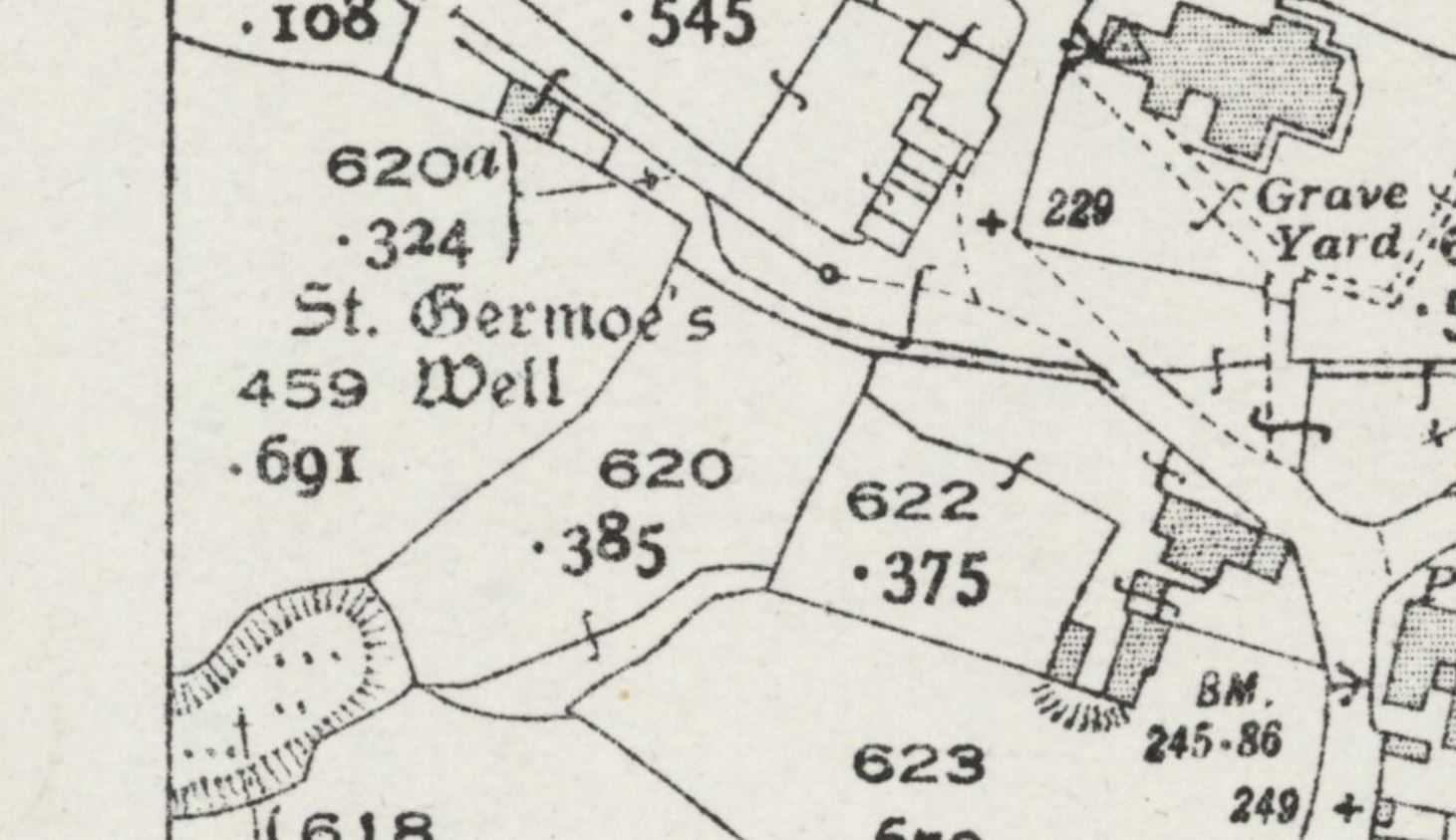
By the early 19th century, St Germoe's Well had mysteriously vanished. I have found no historical references to its existence dating from between the publication of Leland's Itinerary and the early 1800s, so it probably disappeared much earlier than this. In fact, even in the 19th century, it was not frequently mentioned by historians, and most accounts seem to stem from the first volume of The Ancient Cathedral of Cornwall, written in 1804 by John Whitaker, who reported that the "well and tomb are now lost, overlooked and forgotten". In 1824, Fortescue Hitchins (who was from nearby St Hilary, so knew the area well) confirmed this claim in the second volume of his History of Cornwall, in which he described St Germoe's Well as being "completely lost". Evidently its location was no longer known, and had not been clear for some time.
Despite the fact that the well's location was clearly unknown, even to local historians, a spring just south of the church was dubbed "St Germoe's Well" on the 1878 25-inch OS map of Germoe, the first Ordnance Survey map to be published of the area. This spring was continually named "St Germoe's Well" on all later maps too. However, there is no solid evidence to suggest that this spring really was the well of St Germoe, and it is likely that the OS surveyors in 1878 were either misinformed or made an error, which was transferred to all later maps and subsequently accepted as fact. Surveyors are known to have made mistakes like this in the past, notably in the parish of Llanrhaeadr Ym Mochnant, Montgomeryshire, where the local holy well, Ffynnon Dogfael, was errantly placed at the top of a mountain some distance to the north-west, whilst the actual holy well was located near the parish church; this error was transferred to later maps, and consequently caused a large amount of confusion.
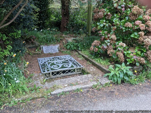
To further the confusion, some modern sources claim that the spring called "St Germoe's Well" on OS maps was either destroyed or severely damaged in 1905, when the adjoining road was widened. However, Ordnance Survey maps do not appear to reflect this change, as they continued to mark the well in exactly the same place until at least 1963, which would suggest that it wasn't actually destroyed at all. Even more confusing is the fact that the structure that today purports to be the holy well was actually "designed and built", according to a plaque that now stands next to it, "by the residents of the parish" in 1977, as an apparently approximate representation of the well that was supposedly destroyed in 1905, but which OS maps indicate existed until at least 1963.
There are several other springs and water sources in the area that may have been St Germoe's true medieval holy well, and whilst the spring that OS maps call "St Germoe's Well" is definitely a likely candidate, there is a high chance that the original well was actually filled in during the Reformation, or perhaps the reign of Elizabeth I. This would explain why it became inexplicably "lost", after it had evidently been popular in medieval times; alternatively, there is a possibility that the original well dried up as a result of mining in the locality. It is worth noting that, if the spring that OS maps claim is St Germoe's Well really was the medieval holy well, then it surely would never have become lost or forgotten, because of its prominent place in the village.
|
|
|
Images:
Old OS maps are reproduced with the permission of the National Library of Scotland
Copyright 2025 britishholywells.co.uk