 |
Dedication: Saint Etheldreda Location: Grantchester Coordinates: 52.17353N, 0.08967W Grid reference: TL429548 Status: destroyed |
HOME - ENGLAND - CAMBRIDGESHIRE
|
Dedication: Saint Etheldreda Location: Grantchester Coordinates: 52.17353N, 0.08967W Grid reference: TL429548 Status: destroyed |
St Etheldreda (or St Audrey) was a 7th century princess and, later, a queen. She was also the abbess of Ely, which held her relics, and her cult was particularly prevalent in the surrounding area. According to the Venerable Bede, sixteen years after Etheldreda's death, her sister Sexburga decided to translate Etheldreda's relics into a new coffin. Upon Sexburga's orders, a search began for stone to make the coffin from; when the search party reached Grantchester, they discovered, leaning against the town wall, a "fair coffin wrought of white stone, furnished with a very proper lid also of similar material", into which Etheldreda's body was transferred. Of course, no legend is complete without the inclusion of a miracle: Etheldreda's body is said to have been found completely uncorrupted when they removed her from her original burial place. Although this establishes a direct link to Grantchester, it does not directly link to the well.
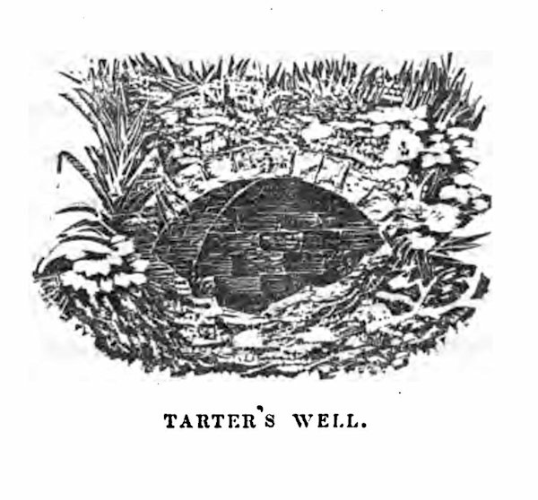
The earliest mention, it seems, of the well at Grantchester is found within a document of 1659 at Corpus Christi College, which describes a portion of land in Grantchester as being bordered on the north by "a common way leading from Lewis Close to Tardreys well". This unusual name for the well has long been believed to be a corruption of "St Audrey's Well", and S. P. Widnall, writing in 1875 in A History of Grantchester in the County of Cambridge (the image above is from this work), showed how the name is believed to have evolved over time in several stages:
|
1. St. Etheldreda's Well. |
Widnall stated that the well, "within living memory" had been "kept in repair and enclosed with brick work, the water constantly flowing from a leaden spout, and even in the driest seasons seldom or never known to fail", and related that "a foot path of pebble stones leading from it to the village was turned up" several years previously during ploughing. However, by 1875, the well had dried up, and only the stone arch remained; according to Widnall, this had been caused by nearby "digging for coprolites".
Nonetheless, the site was both marked and named (always as "Tarter's Well") on Ordnance Survey maps until 1974. At some point before this date, the stone arch had been destroyed, and, today, absolutely nothing remains of the well.
Copyright 2025 britishholywells.co.uk