 |
Dedication: Saint Ann Location: Caversham Status: lost (probably destroyed) |
|
Dedication: Saint Ann Location: Caversham Status: lost (probably destroyed) |
There has been a chapel of St Ann at Caversham since at least the early 14th century, when a chapel of St Ann, located on Caversham Bridge, was granted to the Canons of Notley by a patent of Edward III. In the last century or so, the chapel's patronage has become confused, and it is commonly said that it was dedicated to the Virgin Mary; this confusion seems to have arisen from the fact that the chapel once contained an elaborate image of Mary, although its actual patron was St Ann. Indeed, this image was not the only interesting item that the chapel possessed, and Thomas Cromwell's commissioner, Dr John London, described multiple unique relics that were held within the chapel in a series of letters written to Cromwell in the September of 1536. These included "a peece of the holy halter Judas wasse hangyd withall", the "holy dager that kylled kinge Henry" (along with the "holy knyfe that kylled seynt Edwarde"), and an "aungell with oon wyng that browȝt to Caversham the spere hedde that percyd our Saviour is syde upon the crosse", which itself was "the principall relik of idolytrie within thys realme". Dr London had all of these items completely destroyed, including the silver-plated image of Our Lady of Caversham, which he put in a "cheste fast lockyd and naylyd uppe", before depositing it on a barge on the river. It is clear that this small chapel was successful in attracting a large quantity of pilgrims, and Dr London noted that the walls of the chapel were hung with "lightes, schrowdes, crowchys, and imagies of wex". St Ann's Well certainly had a link to this chapel.
The earliest known reference (and the only historical reference) to the existence of St Ann's Well dates from the early 18th century, when John Loveday mentioned the site in a letter written to Thomas Hearne, regarding the chapel, in 1727:
|
Sir, The gentleman who took in for me a subscription of the work you are now publishing, acquainted me with your desire to know something concerning the quondam Chapel on Caversham Bridge... The father of the present possessor I once asked about it, who told me briefly that it was dedicated to St. Ann, and that from thence the Religious went at certain times to a well now in the hedge between the field called the mount, and the lane called Priest-lane, which is supposed to have its name from their going through it to this well, which was called formerly St. Ann's well. He likewise informed me that there was in the memory of man a large ancient oak just by this well, which was also had in great veneration. |
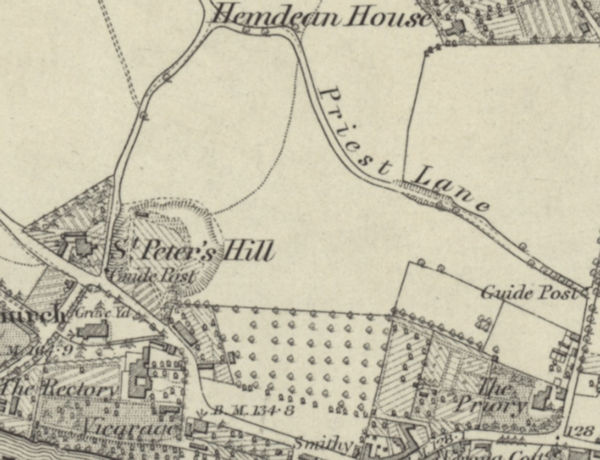
Unfortunately, the exact location of St Ann's Well cannot be stated for certain, simply because of a lack of historical documentation, but place-names that corroborate with Loveday's description indicate the vague area that the well must have been located within. "Priest-lane" was named and marked on first edition Ordnance Survey maps, published in the latter half of the 19th century. The name later morphed into "Priest Hill", the title that the road retains to this day. Although I have no access to tithe map records for this area, the field named "The Mount" was almost certainly the large field once located directly south of Priest Lane; this is indicated by the presence of a neighbouring lane called "The Mount" that ran along the western edge of this enclosure. If Loveday is to be believed, then the well must have been located somewhere along the southern boundary of Priest Lane. To complicate the situation further, the name "St Anne's Road" is something of a red herring, as it was only built in the last century.
Also quite unfortunate is the fact that no historical Ordnance Survey maps mark a well or spring anywhere near Priest Lane, which indicates that the water source either dried up, or was destroyed (the former is more likely, and could have been caused by quarrying in a chalk pit located immediately south of the lane). Alternatively, it is possible that Loveday was incorrect, and that the well was actually much closer to the chapel, in which case it may still exist.
It is worth noting that the Grade II listed deep well that today purports to be the authentic holy well is undoubtedly not the original holy well of St Ann. This well was uncovered by workmen in 1906, and it was assumed, simply because of its location and the fact that the stonework appears to be medieval, that it was the lost holy well. Edward Margrett described the descovery of the deep well in St. Ann's Well and Chapel, Caversham, published in The Berkshire Archaeological Journal in 1906/7:
|
In January last I was told that an old well had been discovered at Priest Hill, Caversham. On visiting the place I found that in the process of making a new road and laying out the land for building purposes, a discovery of some local interest had been made. At the south side of the Priest Hill, at the angle of the new road leading towards the river Thames, there is a dry well about 9ft. deep and about 5ft. in diameter, steined with dressed chalk and flints. The work is much finer than is usual in modern wells and, evidently, was very carefully executed... After careful examination, I concluded that the work was late 15th or early 16th century. |
Although this deep well is clearly of archaeological interest, it is likely nothing more than a domestic well. Authentic medieval holy wells were never deep wells, and always took the form of natural springs, meaning that this simply cannot be St Ann's Well. Indeed, the stonework of the well is of too late a date to have been associated with the construction of the chapel, and it would in fact be illogical to assume that the canons of Notley would have gone to the effort of digging a deep well several hundred metres from their chapel, when there were multiple natural springs (according to historic Ordnance Survey maps) within a shorter distance. Aside from the deep well's location, there is no further evidence to suggest that it was St Ann's Well. It can thus safely be said that this deep well is not the true holy well, despite the fact that a plaque on its new brick well-head proclaims it to be so.
Images:
Old OS maps are reproduced with the permission of the National Library of Scotland
Copyright 2025 britishholywells.co.uk