 |
Dedication: Saint Kyneburga Location: Charlgrave Coordinates: 51.93567N, -0.54611W Grid reference: TL000273 Heritage designation: none |
HOME - ENGLAND - BEDFORDSHIRE
|
Dedication: Saint Kyneburga Location: Charlgrave Coordinates: 51.93567N, -0.54611W Grid reference: TL000273 Heritage designation: none |
St Cyneburgh, or "Kyneburga", was a late 7th century abbess and saint. She is believed to have been the daughter of the pagan King Penda of Mercia, and the sister of St Kyneswitha and, possibly, St Tibba. Traditionally, Kyneburga is said to have been a saintly virgin, but this notion is somewhat contradicted by another tradition that asserts that she was the mother of the three-day-old martyr St Rumbold. Indeed, although Rumbold may very well have never existed, Kyneburga was married to King Alcfrid of Deira, the nephew of St Oswald and son of King Oswiu; she is, however, said to have later left her husband to become a nun. She founded and became the abbess of a double monastery (a form of early Christian monastery that included both nuns and monks) in Castor, near Peterborough, as well as becoming the first abbess of Gloucester. She appears to have been initially buried in Castor, but her relics were later translated to a special shrine, along with those of St Kyneswitha and Tibba, in Peterborough Cathedral. Her relics were of such importance that they were positioned only a few metres from the shrine in which the Cathedral's most important relic, that of St Oswald's arm, was kept. It is not clear what her connection to Charlgrave may have been, but her influence was clearly wide-spread, and she was certainly quite a famous early medieval saint.
St Cyneburgh's Well is possibly the earliest recorded holy well in Britain, and perhaps in the entire world. Its existence was first recorded in a charter of 926 in which King Athelstan granted land in Charlgrave to his thegn Ealdred. The full document is quite lengthy, so below I have reproduced only the part of it that refers to the well: a section of the document that outlines the boundaries of the land:
|
Ðær se dic sceot in wæclinga stræte anlanges wæxlinga stræte ðæt in ðane ford þæt anlang broces in þanne oðerne ford þonne of ðæforde up on þane welle þanan in ðæt dele þanan of ðæm delle in ðone dic of ðæm dic in ðone oþerne dic þone of ðæm dice in þone borc þonne of þæm broce to cynburge wellan þanne anlang dices. to east coten þat þanan in þane ealdan broc up of þam ealdan broce . on æfem ðæt riþig þæt up rihte in ðiod weg æftær ðiod wege in þone dic . æft dice wæxlingga strate. Translation: Where the dyke runs into Watling Street, along Watling Street to the ford, then along the brook to the other ford, then from that ford up to the spring, and thence into the valley, thence from the valley to the dyke, from the dyke to the second dyke, then from that dyke to the brook, then from the brook to "cynburge wellan", then along the dyke to Eastcote, then thence to the old brook, up from the old brook parallel with the little stream, then straight up to the highway, along the highway to the dyke, along the dyke to Watling Street. |
The site was again referenced, albeit indirectly, in a court roll of Charlgrave Manor on the 11th of June, 1313, which mentioned land at "Cumberwell". A court roll of 1586 also mentioned a furlong of land known as "Kymberwelle"; in 1647, this was called "Kimberwell Furlong", and, by 1797, it was known as "Kimberlake Furlong". It is not known exactly where this piece of land was located, but it was certainly situated somewhere within Charlgrave parish.
Although the well was evidently a notable feature of the parish in 926, it does not appear to have had any special significance during the rest of the medieval period. The corruption of the name "cynburge wellan", or "Cyneburga's Well", into "Kimberwell" may account for this, although the spring was reportedly used as a cure for, typically, weak eyes. In volume 5 of the Publications of the Bedfordshire Historical Record Society, published in 1920, it was noted that "within memory the spring of Kimberwell was much resorted to for the cure of weak eyes", and that people once came "from considerable distances to carry away the water in bottles". In fact, the society was "given the name of a man who still does so".
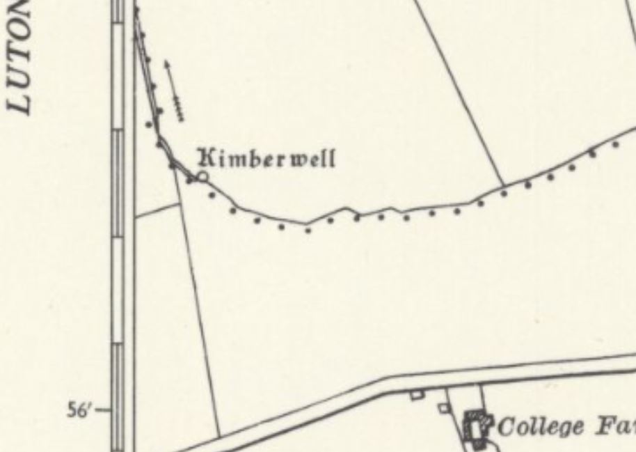
Despite the fact that it was known locally until the 1920s, the well was never named or even marked on Ordnance Survey maps until 1960, perhaps because it was, at least by 1933, nothing more than a marsh. When the well was visited by OS surveyors forty years later, in 1973, they described it as "a seepage of water from a marshy area". In 1960, the well enjoyed its first and last appearance on an Ordnance Survey map, which called it "Kimberwell" (see the image above). Today, the site's condition is not certain, as it is no longer marked on Ordnanc Survey maps, or named.
|
Access: The well is located on private land. |
Images:
Old OS maps are reproduced with the permission of the National Library of Scotland
Copyright 2025 britishholywells.co.uk